“Can you feel what this air is like? Delicious, juicy, so good you can spread it on bread,” says Vadym breathing deeply. He came to Korabelka with a group of tourists from Mykolayiv to celebrate the holidays. Korabelka is the name given to the area where the small River Korabelna flows into the Southern Buh (photo 1). We descend from the road down into the valley. The air is truly great – it smells of grasses, warmed by the rays of the sun. On this rocky path, every other step causes lizards to slip out from underfoot. A small peninsula appears in front of us. We set up camp here, under a well-formed bridge between the two rivers.

A VILLAGE OF COSSACKS AND OSTRICHES
Part of the group remains at the camp while another takes a short bus-ride to Myhiya in the Pervomaisky district. “It’s an ancient village. A Cossack winter camp was founded here in the early 18th century,” says the guide, Oleksandr. “Legend has it, that once upon a time, Turkish territories were on the other side of the river. When Cossacks lit their fires at night, they flickered in the distance, which is where the village got its name from. They also say that this is the birthplace of Cossack Mamay. I’m not sure this is true, but one of the islands on the river bears his name."
Today however, there is little evidence of the legendary past. Just about one house in three along the road is ruined, and the road bridge in the middle of the village has a long hole right down the middle. On the other hand, for some reason, the local restaurant welcomes guests in English and German, offering ostrich dishes.
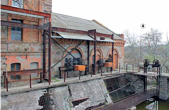
The old power station (photo 4) is nearby. The red-brick building appears to be frozen. The wheels that were once turned by turbulent water are now covered with rust in places. There is a warning sign before the narrow path to the bay – entrance to the waterworks is prohibited. But the bungee rope, hanging over the water just under the wall of the power station, clearly indicates that the locals are ignoring the ban. A fabulous landscape lies in front of the facility: flat, mirror-like water abruptly breaks off, creating a small waterfall, flowing rapidly, gaining strength at each subsequent rapid, going on and on until it finally disappears around the corner.
A RAFTING PARADISE
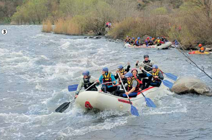
Most cars on rural local roads carry rafts (small inflatable boats). “People often raft down the river here. They train and compete here. These are the second most difficult rapids in Ukraine”, says Oleksandr.
Within a few minutes, we can see the training for ourselves (photo 3). They can be seen from the cliffs rising above the river. At the bottom, as if on the palm of a hand, the channel makes a sharp turn, which is where we see several rafts, about 10 rowers in each and a couple of single-person canoes, that throw themselves into the elements one after the other. They try to fight the current, but the water carries them back and often tips them over. But they don’t give up – they circle around and plunge into battle once more.
An abandoned granite quarry lies ahead. People have left a huge wound in the cliffs, which go into the depths of the earth in spiral circles. It is now filled with calm and clean water, reflecting the blue sky. “They say that when the granite became radioactive, the quarry was closed in such a hurry, that an excavator was forgotten at the bottom. It is supposedly still under water at a depth of 60 meters,” says our guide. “My friends planned to dive into the so-called Black Lake to see if this is true. But I don’t know if they succeeded.”
THE RANSACKED MILL
It was already raining in the morning of the next day, but we still choose to do some more wandering. We cross the river to the other side of the river and go towards the village of Semenivka. “Yesterday a travel guide competition was held on the opposite hillside. This was the perfect spot from which to watch who was running where, and how others searched. In some cases people were constantly walking back and forth around the control point but could not find it,” shares Oleksiy, a member of our group. “This competition was organized by people from Pervomaisk. There were few willing participants – only one bus and nearly 10 cars.”
This is not the first time that Oleksiy has visited these places, so he knows a lot of stories. “At one time, there were difficulties in growing trees here, just as in most parts of the region. There was a landowner, Skarzhynsky, who established a tree nursery in his native village, Trykraty, not far from here. He worked on acclimatizing trees and bushes, brought to him from South America and Western Europe. They were then planted all around the area. We will walk past a rare old poplar. They say that Skarzhynsky himself planted it. Well maybe not by him personally but definitely during his lifetime.”
A little further on from poplar, which does indeed look majestic, we find what we were looking for in spite of the rain: the ruins of the old mill. It was probably a nice building once upon a time, but now, all that’s left are bare, half-ruined walls, through which trees are growing. “This mill was probably built during Tsarist period. It was closed in the 1960’s and the building that had always been kept in good condition, was used as a warehouse. In the 1990s it was ransacked. People came in cars and dragged out all the iron, which could be sold as a scrap. This is what that’s left, but it could have been a tourist attraction,” notes Oleksiy sadly.
TOURISTS’ CORNER
On the way back, we meet a young man who is collecting the ropes that are tied to the pillars of the bridge. It appears that jumpers often use this bridge. We also met a group of a rock climbers from Mykolayiv. They train on the rocks next to our camp organizing the jumping as entertainment for themselves. “We jumped yesterday. But not today – all the ropes are wet from the rain,” says the young man.
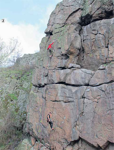
The sky finally clears in the afternoon and the rock climbers begin their training (photo 2). There is only a small piece of land at the foot of the rocks, where those ensuring the safety of the climbers stand. All spectators sit on the other side of the river, which can only be crossed with the aid of two taut cords.
“My trips to Korabelka are a traditional opening of the season,” says Alla, an experienced tourist, when talk turned to the fate of these places and tourism. “The only difference is that my earlier trips involved more sport. Here we prepared for serious treks in the Caucasus, for example. Now it is all about having a rest. Some young people still continue our tradition – hiking is a way of life for them, as it once was for us,” she says of the boys and girls training on the nearby rocks.
She also says that the regional Granitno-Stepove Pobuzhzhya (Granite Steppe Buh Area) nature reserve, which is where we actually are, is the winner of The 12 Wonders of Mykolayiv contest. “Potentially this is a great place for tourism and it could even bring fame to our region. But it seems that no one needs this, neither the government nor the locals,” adds Oleksandr. “This might even be better for us – we have our own little corner where we can hide from civilization and all everyday problems. Some cell phones don’t even get a signal here.”
THE GRANITE STEPPE
This nature reserve in the southwest of Mykolayiv Oblast is located in the part of the Ukrainian Shield, which hasn’t been covered by sea for nearly 60 million years. There are massive granite boulders on the rocky banks of the tributaries of the Southern Buh River, that are 40-60 meters tall. This area was granted the status of a nature reserve in 1994. The park covers an area of 6,267 hectares and has a unique ecosystem. About 900 species of vascular plants, more than 9,000 species of insects and nearly 300 species of vertebrates grow here. The variety of fish found here includes, for example, the Dnipro barbel (of the carp family), which is only found in this area. The Danube shemaya (royal) fish, the Aesculapian snake, the yellow-bellied snake, the Saker falcon, the booted eagle, the European otter and badger are among other rare inhabitants of the Buh region. In all, 86 species of flora and fauna in the Buh region are on the endangered list. Plant and animal relicts of Mediterranean and Alpine origin can also be found here.
WORTH SEEING:
Hydroelectric Power Station
A former water mill, built in Myhiya by the Skarzhynsky family, which, during the Soviet era, was reconstructed as a hydroelectric power station.
The Myhiya Rapids
A network of rapids and rifts in the Myhiya and Southern Buh River region. The water (boating) tourism route is the second most difficult one in Ukraine
Black Lake
An abandoned granite quarry, on the site of which a large lake was formed
Water mill
The ruins of the old water mill in the village of Semenivka. It was used as a warehouse for a while and was ransacked in the 1990’s
HOW TO GET THERE:
Take the train to Mykolayiv, then take buses and fixed route taxis going to Pervomaisk