Massive floods were part of the numerous natural disasters that befell mankind in the nearly three million years of its history. These global catastrophes are mentioned in the Holy Scriptures as the Great Flood in the story of Noah’s Ark.
The era of floods which were truly catastrophic for Europe (including Ukraine), which was in close proximity to melting glaciers, can be identified as the period of the intense melting of the last glacier, 13,000-10,000 years ago, known as the late glacial epoch or the final phase of the Palaeolithic age.
THE HIDDEN RESOURCES OF THE LAST GLACIER
At the peak of freezing temperatures 20,000-17,000 years ago, large masses of water were bound by ice, and the level of the World Ocean dropped by 130m and that of the Black Sea by 100m. As a result, the shallow continental shelf which lay 100-130m deep (calculating from the present level of the ocean), became dry land. Shallow seas along the northern coast of Eurasia disappeared, while the northern coast of Siberia was hundreds of kilometres closer to the North Pole than it is now. At that time, the Bering Strait between Asia and North America did not exist. What is now the Bering Sea was the Beringia plain across which Asian people travelled to settle on the American continent 13,000-12,000 years ago.
After a significant drop in the ocean level, a plain, full of verdant vegetation sprawled between Britain and Scandinavia. It served as summer pasture for numerous herds of bison, moose, wild horses, saigas (antelopes) and mammoths and as hunting grounds for the Cro-Magnon men of the Upper Palaeolith. From time to time, fishermen’s trawlers bring in not only antlers and mammoth bones from the bottom of the North Sea but also spearheads and harpoons used by hunters from the Ice Age.
The deep-water exploration of submerged continental slopes has revealed a clear coastline along their perimeter, 130m under the surface of present-time oceans, with characteristic beaches, dunes, bluffs, etc.
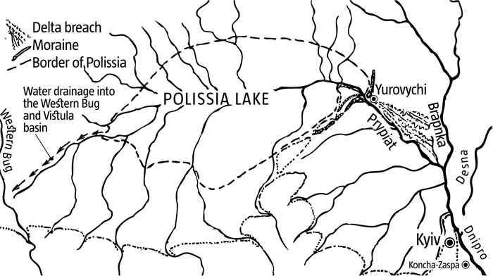
The near-glacial Polissia Lake 13,000 years ago
Rising temperatures in the late Ice Age caused frozen water to quickly melt. Huge masses of water poured into the World Ocean, significantly raising its level. Low-lying lands were sometimes flooded in a catastrophic fashion, even though the process lasted several millennia.
It is well known, that spring floods are caused by rapidly melting snow and ice accumulated over several winter months. Imagine the scale of floods in the late phase of the Ice Age, when an ice crust, built up over the course of 20,000-30,000 years, turned into water! Great ice sheets melted, releasing powerful torrents of water.
Gigantic streaks of frontal moraines were formed along the southern edge of a glacier. These were tall ridges of rock and sediment that stretched for thousands of kilometres across northern Germany, Poland and Belarus to Russia and the upper Volga River. Numerous lakes, often creating entire cascades, were formed in them. When temperatures rose, the surface of a glacier would melt faster and vast masses of water overfilled the lakes, breaking dams in the form of moraines, flowing in ruinous torrents. As they moved along river valleys, they smashed and carried along everything that stood in their way.
Periods of ice melting were accompanied by catastrophic floods, colossal shifts and mud flows. Vast areas of the continental shelf were flooded due to rapidly rising ocean water, caused by the inrush of hundreds of thousands of cubic metres of ice water.
THE POLISSIA-DNIPRO FLOOD
The Prypiat lowland, through which the Prypiat River and its tributaries flow, is shaped like a saucer. The southeastern edge of this saucer was formed by ridges of Ice Age moraines in the area where the Belarusian city of Mazyr is now located in the low Prypiat area. The moraines emerged at the peak of the Ice Age, around 250,000 years ago. Their ridges rise 30-50 metres above the surface of the lowland, blocking passage eastwards to the valley of the Dnipro River, which carries its waters down to the Black Sea. It was this saucer-like depression with its natural moraine dam to the east, that helped the near- glacial Polissia Lake to emerge.
Throughout the 20th century, geologists — notably Kyiv-based geomorphologist Vasyl Pazynych towards the end of the century — worked on the concept of the existence of this lake, the waters of which periodically burst into the Dnipro valley. Proof of its continued existence, are the major deposits found by Belarusian scientists in the Prypiat basin. Dammed by the moraines, the lake discharged its waters to the west, into the Western Bug and Vistula basin. It accumulated colossal amounts of water (up to 400 cu km) from melting glaciers. The lake was formed and burst into the Dnipro many times over during the Ice Age, ruining the valley of the river down to its delta. The last burst took place 13,000 years ago, when intense melting caused the dam to burst and the Prypiat to flow through the breach.
This flood wreaked havoc with the valley and its inhabitants. A powerful blast of water thrust large masses of sand, gravel and clay through the breach near what is now the village of Yurovychi in the lower Prypiat area. Carrying this moraine debris, torrents of water rushed southwards along the valley of the Dnipro towards the Black Sea, levelling terraces and leaving behind thick sand deposits. Geomorphologists have found traces of this ruinous torrent in the topography of the Dnipro’s valley.
A powerful mud flow from Polissia left behind several metres of sand in different areas, including a multi-kilometre stretch of sand deposits in the flood plain along the Dnipro’s right bank, downstream of Kyiv.
Dating these disastrous floods that reached all the way to the Black Sea is possible thanks to archaeological finds located directly in the sand deposited by the floods. The breach, located 20km southeast of the Mozyr moraine ridge is of particular scientific interest. The waters of the lake made a 2.5-kilometre opening in the long, 40-metre high ridge through which the Prypiat now flows. Yurovychi is located directly at the entrance to the breach. There is a raised sandbank in its vicinity, where a remarkable series of arrowheads of the Swiderian culture, made 11,000 years ago, were found. People were clearly able to live in the breach when the lake was no longer there, with only the Prypiat crossing what used to be its bed.
The grand flood caused 13,000 years ago by the bursting Polissia Lake was the last major natural factor that contributed to the formation of the current Dnipro valley on Ukraine’s territory. The drainage of the Polissia Lake made the vast Prypiat and upper reaches of the Dnipro basins inhabitable.
THE BLACK SEA DELUGE
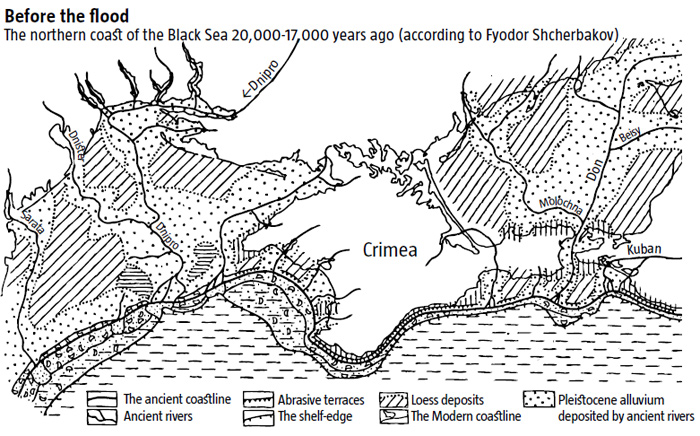
With the level of the Mediterranean Sea falling at the peak of freezing 20,000-17,000 years ago, it lost its connection to the Black Sea via the Bosporus and the Dardanelles. Coupled with a significant reduction in the influx of river waters, due to the dry and cold climate near glaciers, this factor brought down the level of the Black Sea by 100m, which, in its turn, led to the sea’s desalination. Shallow patches of its bed along the coastline became exposed, forming the Black Sea shelf. The northwestern coastline of the freshwater Black Sea lay 200km to the south of Odesa. The Sea of Azov did not exist at the time, and the Don River flowed across what would later be its bed and discharged into the freshwater Black Sea, south of the Kerch Peninsula. Lowlands stretched between the Crimea and what is now the mouth of the Danube, intersected by the valleys of the Danube, Dniester and Dnipro rivers. About 100km south of modern Odesa, the Dniester flowed into the Dnipro, the mouth of which was on almost the same latitude as Simferopol.
The dry grassy steppes, where herds of bison, horses and other herbivores roamed in the late Ice Age, extended far to the south of the steppe area north of the current Black Sea, covering the entire territory of the Sea of Azov and the Gulf of Odesa. Along the edge of the Black Sea shelf, a coastline with characteristic bluffs, pebble, sand beaches, dunes, etc. was found at a depth of about 100 metres.
Towards the end of the Ice Age, floods like the one that swept across Polissia occurred throughout the territory adjoining glaciers in the Northern Hemisphere. Huge masses of ice water from vast frozen expanses in Scandinavia, Siberia and North America poured into the World Ocean, steadily raising its surface level. Lowlands along continental coastlines were flooded and turned into continental shelves.
READ ALSO: Climate Creates History
Rapidly melting glaciers quickly filled the rivers of the Black Sea basin 15,000-10,000 years ago. Ice water from the Valdai glacier drained southwards along the Dnipro and the Don. The Danube carried masses of water from the eroding glaciers of the Alps and the Carpathians, and the Kuban from the Caucasus. Excess freshwater flowed over from the brimming Caspian basin along the Kuma-Manych Strait to the Black Sea, causing its level to rise erratically but continually during the Ice Age, thus gradually submerging its coastline areas.
Towards the end of the period, about 9,500 years ago, freshwater from the Black Sea began to spill over through the Bosporus and the Dardanelles. The salty water of the Mediterranean Sea contributed to the gradual salination of the Black Sea, causing a layer of hydrogen sulphide to form on its bed. The erratically but continually rising level of the Black Sea in the late Ice Age caused the vast steppes north of the Black Sea and near the Sea of Azov to be covered by the water of what is now the Gulf of Odesa and the Sea of Azov.
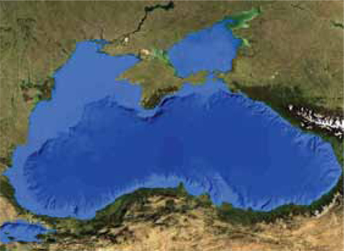
The Black Sea as seen from outer space. Light-blue marks the areas that were submerged after the Ice Age
The scenario under which the Black Sea level gradually rose was developed by Ukrainian and Russian scientists back in Soviet times. An alternative to it is the hypothesis of a catastrophic Black Sea deluge. It was proposed in 1993 during an international scientific expedition on the Aquanaut along the Black Sea shelf. The expedition was led by William Ryan and Walter Pitman of Columbia University, and their results were published in a book with the intriguing title Noah’s Flood in 1999.
Supporters of the Black Sea deluge theory came to the conclusion that during the coldest period, 18,000 years ago, when the level of the World Ocean was much lower than today, there was a ridge of hills linking Europe and Asia where the Bosporus is now. Ryan, Pitman and their followers believe that unlike the Mediterranean, the level of the Black Sea, which was isolated from the World Ocean, did not rise and was 150m lower than it is today.
While the Black Lake was allegedly drying up, like the Aral Sea in our day and age, ocean waters continued to rise consistently. Proponents of the Black Sea deluge suggest that about 7,600 years ago, waves from the Mediterranean reached the Bosporus depression and spilled over in the form of a giant salty waterfall (according to various estimates, 100-150m high) into the freshwater Black Lake. According to this scenario, the flow of saltwater was so powerful, that the lake rose by 15cm a day, and the sea advanced into the lowlands of what is now the Gulf of Odesa at a rate of several kilometres per month. Two to three years later, the level of the Black Sea rose by at least 100m, flooding the lowlands along its western and particularly its northern coast.
The rapid salination of what was a freshwater lake with sea water proved fatal to its flora and fauna. With all living organisms dying almost instantly, the bed was covered by a thick layer of dead organic matter. Because of a lack of oxygen, its decomposition caused the formation of hydrogen sulphide at great depths.
Despite its popularity, the dramatic concept of the Black Sea deluge has weak points, for which it has been criticized by specialists who favour the theory of gradual transgression. Among other things, it is hard to explain the shrinking of the Black Sea at the peak of glacier melting in the final phase of the Palaeolithic age 15,000-10,000 years ago, because the erosion of the Valdai, Alpine-Carpathian and Caucasian glaciers brought more water to the Danube, Dniester, Dnipro, Don and Kuban. The drainage of the Polissia Lake alone pumped about 400 cu km of water into the Black Sea basin. This is the reason why the level of the Black Sea did not drop in the final millennia of the Ice Age, as deluge theory proponents suggest, but, on the contrary, rose even faster than that of the World Ocean. This would have inevitably caused, first, the flooding of shelf areas along the coast and then the drainage of excess freshwater through the Bosporus into the Mediterranean. In view of the above, the deluge hypothesis should be treated with caution.
READ ALSO: The New Climate Era
Moreover, some of its supporters claim that the biblical story of the Great Flood describes the deluge of the Black Sea coast. The biblical testimony that “all the floodgates of the sky were opened, and rain fell on the earth for forty days and nights”, appears to be more like monsoon rains on the coast of the Indian Ocean than a deluge in the temperate climate north of the Black Sea.
It has been suggested that Plato’s mention of Atlantis suggest a Pontic civilization buried under the Black Sea. However, modern archaeology has found no evidence of any ancient culture at the bottom of the Gulf of Odesa. If the sea incursion advanced at several kilometres per month, as the deluge theory suggests, most of the population on that territory was able to flee. However, no traces of societies that would have developed enough to have cities, a writing system and a state, have been found along the western and northern Black Sea coast.
Equally implausible is the hypothesis that Sumer in southern Mesopotamia was founded by the Pontic people who fled from the Black Sea deluge. They are claimed to have brought with them the legend of the Great Flood, leading to the Sumerian myth of Gilgamesh which later allegedly morphed into the biblical story of Noah’s Ark. However, Mesopotamia had no need to import legends about catastrophic floods, having a rich history of them on its own annual large-scale flooding by the Tigris and the Euphrates and the flooding of the Persian Gulf by the Indian Ocean.
Therefore, most contemporary scholars tend to reject the deluge theory in favour of the gradual incursion of the sea into low-lying coastal areas.
Accompanied by gigantic cataclysms, large-scale natural-climactic changes at the end of the Ice Age brought about the fairly warm climate that we are experiencing now and shaped the modern contours of Europe, putting natural preconditions in place for its northern part to be populated and laying the foundation for the ethno-cultural map of northern Eurasia.